Newcastle International Airport (NCL)
City Orientation and Maps
(Newcastle, England)
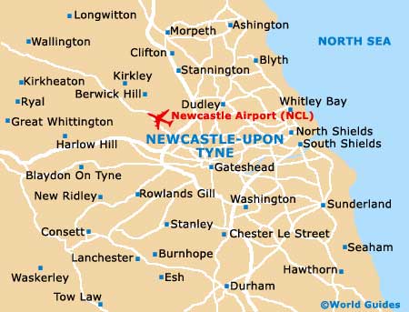
The city of Newcastle upon Tyne is located in the county of Tyne and Wear, on the north-eastern side of England. Newcastle is close to the coastline and lies directly west of both Whitley Bay and South Shields.
Other nearby locations close to Newcastle include Gateshead to the south, Sunderland to the south-east, and Cramlington to the north. Those looking to travel further afield will find Newcastle upon Tyne close to a number of major UK cities, such as Leeds, which stands around 166 km / 103 miles to the south of Newcastle, York around 145 km / 90 miles to the south-east, Manchester approximately 233 km / 145 miles to the south-west, and Sheffield around 219 km / 136 miles directly south.
Also within easy driving distance of Newcastle, Birmingham is around 334 km / 208 miles away, to the south, while Nottingham lies 259 km / 161 miles to the south-east. London can be reached in around four and a half hours, being situated 450 km / 280 miles to the south-west of Newcastle.
Newcastle International Airport (NCL) Maps: Important City Districts
The centre of Newcastle is located to the north of the River Tyne and is connected to a number of modern developments on the southern side of the city by a series of bridges. Central Newcastle is easy to walk around and also features an underground train network, which is known as the 'Metro'.
The main train station in Newcastle is sited on the southern side of the city centre. Newcastle's coach station stands along Gallowgate, while the bus stations can be found at both Haymarket and on Eldon Square.
England Map

Tyne and Wear Map

Newcastle Map